
iphone
There are 38 posts tagged iphone (this is page 2 of 2).
Äs steit auso no…
Ein schöner Einstieg in die Wintersport-Saison, Thunersee
Heidsee, sommerlich
Thunersee, von der Baachegg
Hihi!
Neuenburgersee
Go!
Vierwaldstättersee
Saisonabschluss par excellence!
Leider hat sich der Bebilderer nicht ruhig halten können, deshalb ist sein Arm verschwommen :)
from Flickr via IFTTT.
Where was I in 2014
This is the first second of some of my look back on 2014 posts. To see the other ones, take a look at the jahresrückblick14-tag
Introduction
I tracked my location data with OpenPaths since the beginning of 2014. OpenPaths comes as an application for your phone, which tracks its location, uploads it to the OpenPath servers, where you can donate your data for scientific research, and look at the data yourself.
To do this, we grab a .CSV file with the location data. Log in to OpenPaths, and click on CSV under Download my data, which gives you a comma separated list of your location data, which can then visualize with R, which is what we’ve done here.
Data
We want to plot the location points on a map, which we can do with the wonderful ggmap library. First, we load the CSV file and display a summary of the data.
[code lang=r]
library(ggmap)
data summary(data$lat)
summary(data$lon)
summary(data$alt)
[/code]
[code lang=text]
## lat
## Min. 1st Qu. Median Mean 3rd Qu. Max.
## 34.6 46.9 47.2 46.0 47.5 53.6
## lon
## Min. 1st Qu. Median Mean 3rd Qu. Max.
## 4.76 7.50 8.20 21.80 8.22 141.00
## alt
## Min. 1st Qu. Median Mean 3rd Qu. Max.
## -48 353 380 463 546 2670
[/code]
In 2014 I was somewhere in woods somewhere in Romania in the mean, and somewhere in Beromüster as the median.
[code lang=r]
summary(data$device)
summary(data$os)
[/code]
[code lang=text]
## device
## iPhone4,1 iPhone6,2
## 13453 1093
## os
## 7.0.4 7.0.6 7.1 7.1.1 7.1.2 8.0 8.0.2 8.1 8.1.1 8.1.2
## 829 261 2238 2065 1551 145 6095 479 449 434
[/code]
We see that in 2014 I changed from an iPhone 4S (iPhone4,1) to an iPhone 5S (iPhone6,2) and went through 10 different iOS version numbers.
Location data
Extremes
Interesting points in our data are
- The minimal and maximal latitudes of 34.601 and 53.5866, South and North.
- the minimal and maximal longitudes of 4.762 to 141.1744, East and West.
- as well as the altitude, which ranges from -48 AMSL to 2671 AMSL.
We can get the extreme points out of the data pretty easily. To do so, we subset the data depending on the value we want to have, build a Location from these points, grab the map from that location, display this map and add a pointer.
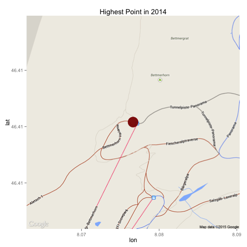
For the most northern point, this goes like so:
[code lang=python]
NLocation = c(lon = subset(data, lat == max(data$lat))$lon[1], lat = subset(data,
lat == max(data$lat))$lat[1])
mapImage zoom = 15)
ggmap(mapImage) + geom_point(aes(x = subset(data, lat == max(data$lat))$lon[1],
y = subset(data, lat == max(data$lat))$lat[1]), alpha = 0.5, color = "darkred",
size = 10) + ggtitle("Northmost point in 2014")
[/code]
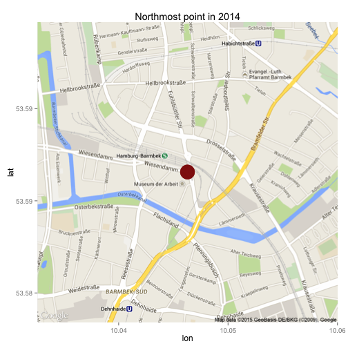
We see that in 2014 I was in Hamburg, which is the northmost point. Correctly, the northmost point would be in Oslo, where I spent New Years Eve 2013/2014, but I’ve only really started to use OpenPaths in mid-January 2014…
The rest of the extremes can be extracted accordingly.
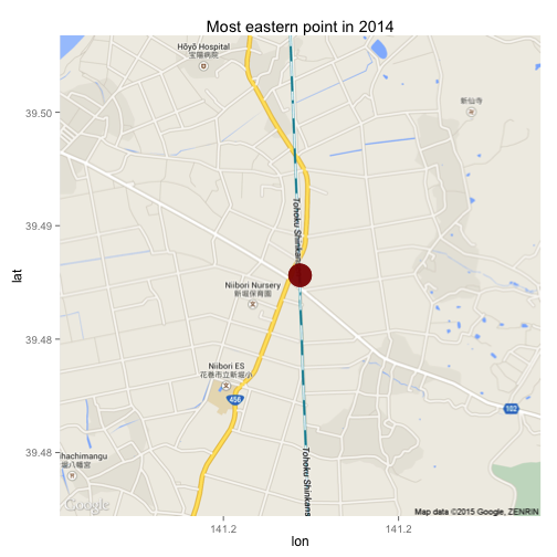
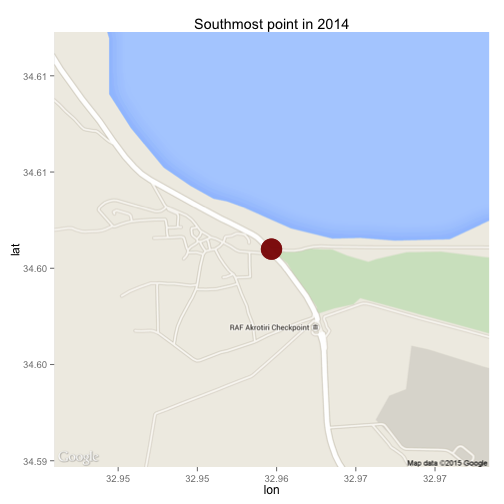
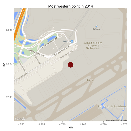
The most eastern point was (unsurprisingly) in Japan, the southmost point in Cyprus and the most eastern point in Amsterdam (while flying to Japan).
The highest peak I reached in 2014 was the Bettmerhorn, probably while skiing. The lowest point at -48 AMSL was at home and is probably a fluke in the GPS data :)
Where was I in Switzerland?
To plot the obtained data on a map, we have to center the resulting map location. Since I only want to show the data points in Switzerland, we center the map on that. Afterwards, we can simply plot all the data points on top of that image, and you can see where I was in Switzerland in 2014.
[code lang=r]
HomeBase zoom = 8)
AllPoints ggmap(HomeBase) + geom_point(aes(x = lon, y = lat), data = AllPoints, size = 3,
alpha = 0.25)
[/code]
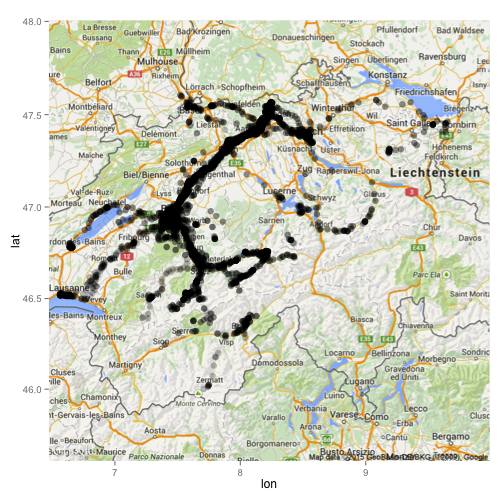
If you’d like to see the full R code (in R Markdown), you can take a look at the OpenPaths.Rmd on my GitHub account.
Rolex Learning Centre, EPFL Lausanne
Also, wenn ich das nächste Mal ein Meeting an der EPFL in Lausanne habe, muss ich meine Panorama-Ausrüstung mitnehmen. Mit der 360Panorama-App sieht das Rolex Lernzentrum schon nicht allzuschlecht aus, aber da wäre noch mehr rauszuholen :)
iTunes update-check #fail
is this a known problem for other iphone-owning readers of my blog?
iTunes tells me that there are updates for iPhone applications, I click on the “check for updates”-button and iTunes tells me – sometimes twice – that updates for my programs are available. i thus have to click multiple times to see the updates of which I already know that they’re available… quite annoying, don’t you think? does one of my readers have the same problem and even knows a resolution? I’d like to hear your tips.
a short screencast describing the problem can be seen below:
oh, and this post is also a test of jing :)
panoramas from (low quality) movies [update]
whenever i’m spending a day outdoor, i love to take pictures, many of them turn out to be panoramas.
sometimes i leave my camera at home and only have my mobile phone with me. shoothing panoramas with the iphone is possible with panolab [link opens itunes], but very cumbersome. and i try to keep the annoyance of nina as low as possible while stopping on the slopes, so fiddling with my phone for longer than a minute or two is not an option.
recently i was thinking about a quick-and-dirty way of creating panorams with the iphone: wouldn’t it be possible to extract the images of a movie shot while panning the scenery and stitch those together to generate a panorama? today was the perfect way to test this out, on the slopes of the wonderful stockhorn.
the whole process is fairly easy, you only need
- an iphone, jailbroken (or any other movie source :) ) with cycoder installed
- cyberduck or winscp, depending on your platform
- imageJ and
- hugin
all these – very fine – pieces of software are freely available, most of them even free as in beer and as in speech.
step 1:
shoot a movie.
below are the movies i’ve used for this tutorial. both are made with the excellent cycoder.app, only for jailbroken iphones. use any other movie if you don’t have an iphone :) the movies are 384×288 pixels in size, as shown below, just press the play-button.
step 2:
get the movies off your iphone.
cyberduck and SFTP are my weapons of choice, YMMV, but there are tons of tutorials on the web, here’s one for the mac and here’s one for windows.
now you should have some movies on your hard-disk. cycoder has the nice feature to produce quicktime-compatible .mov-files, if you don’t have one of those handy, again, YMMV. (use the excellent handbrake to convert to and fro). quicktime is nice for the next step.
step 3:
import the movies into imageJ.
if you’re on a mac, this is just simple drag-and-drop, on windows you might be quicker altogether if you convert your movies to .avi-files, since installing quicktime for java can be a bit of a hassle, but can be done.
this opens your quicktime movie as a stack of images you can then scroll through. this image-stack can then easily be exported as an image-sequence using “File > Save as > Image Sequence…”. rotate the images if you’ve been dumb enough to hold the iphone wrong :)
then you’ll have a bunch of single images on your harddisk. if you’ve panned quite slowly like i have done, you’re probably gonna have much too many images (167 for the first and 139 for the second movie) to easily stich a panorama. for these movies, i’ve removed some images from the stack using the slice remover plugin. remove slices that are unnecessary like the ones at the beginning and the end, where your glove covers the lens. now having 20 and 32 images from both movies, proceed to the next step.
step 4:
import the images from the step above into hugin, align and stitch.
yes, that’s it, it’s really that easy. for the movies shown above i’ve also deleted some bad control points and stitched the panoramas normally and enfused, but this is entirely optional.the end-result looks like the images below. click them to see them bigger.
i know that both panoramas are not perfect. both are quite small, especially the second one has some artifacts and both have varying exposure. but keep in mind that i’ve only bothered nina for 29 seconds, the total time of both movies. not too shabby!
update:
arru from sweden left a comment about extracting the frames of videos using VLC, which is great, because it plays pretty much any movie-format.
since i couldn’t find it, i asked him to outline it for me via email. he agreed that i share his howto, which you can find below:
Extract frames in VLC:
- Open VLC preferences, select “all” (as opposed to “basic”)
- Go to Video->Output modules
- Select ‘Image video output’ (this must be reverted to ‘standard’ when you’re done, to use VLC as a normal video player again)
- Flip down the subgroup next to Output modules and select ‘Image file’
- Choose ‘PNG’ as format (JPEG works too, but there will be some unnecessary quality loss)
- Set ‘recording ratio’ to 10 (determines the number of video frames skipped between images – may need to experiment with this value if images don’t overlap correctly)
- Press ‘save’ to exit VLC preferences
- Open and play the video in question as you normally would (notice: there will be no picture – sound however, if applicable, and the VLC controls will move to show you the progress of the conversion)
- Images are saved to the root of the main HDD on Mac OS X ( / ), on Windows I can only assume it will be C:
- Don’t forget to reset step 2 to ‘Standard’ when you’re done
- Throw images into Hugin and run one of the autopano scripts, and so forth
Thanks for that info, Arru!
i’m offline
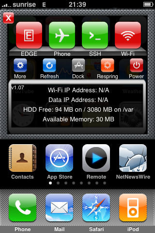
it seems harder and harder each year: whenever holiday season comes nearer, i by choice try to stay completely offline, so i can conquer my extralineophobia [1], read some books, go for walks, go skiing, cook nice and take some pictures (not that I buy a new camera each year). so, i’ve shut down my computer and switched off EDGE and WLAN on my phone, so I shouldn’t be too tempted to go online for the next few days. i’ll be back sometimes in early 2009. cu!
[1]: a term originally coined by pieceoplastic
[2]: the iPhone-application seen is SBSettings, only available on jailbroken iPhones…
softwaretipp für’s iphone
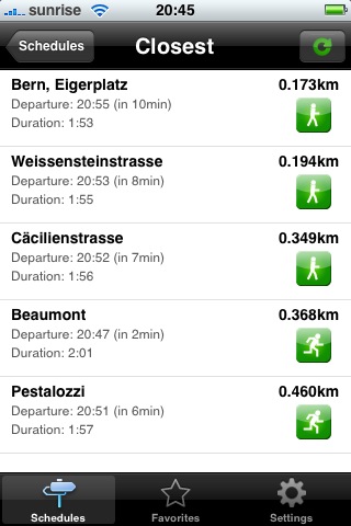 gottago [1], ein projekt von codesofa.com und liip.ch ist eine ausgefuchste software für das neue iphone, welche dank der location-awareness des iphone den momentanen aufenthaltsort rausfinden kann [2] und dies direkt mit einer fahrplanabfrage der sbb verbinden verbindet.
das alleine ist schon mal ein killer-feature für diese auch schön gemachte applikation, aber dass ich in zukunft nicht mehr die etwas mühsame mobile seite der sbb aufrufen muss, ist natürlich auch super. denn eine fahrplanabfrage gestaltet sich mit gottago viel schneller und auch schöner. jedem auch nur manchmal-zugfahrer mit iphone im sack sei das stück software wärmstens ans herz gelegt!
bravo!
auf dem liip-blog hat’s noch ein paar mehr informationen dazu und auch ein nettes filmli, das die integration der google-maps applikation zeigt.
[via fscklog]
[1]: der link führt direkt in den itunes appstore
[2]: das funktioniert mit der neuen firmware auch bei meinem “alten” ohne gps wunderprächtig. die position ist dann halt einfach der momentan eingebuchte mobilfunkmast, aber bei öv-haltestellen sind das ja problemlose distanzen.
prioritäten…
mein sms aus dem zug an kollege: “hey —–. bisch o am luege?: www.macrumorslive.com gruess usem zug. habi”
sein sms ca. eine halbe stunde später: “ja, und es isch e mega kuule match. vorem moleson. wo luegsch du fertig? gruss —–“.
ich hab’ echt nicht daran gedacht, dass die schon wieder schutten…
und nur, damit’s allen klar ist: herr jobs hat heute das neue iphone mit gps und 3g und sonstnoch viel coolem vorgestellt, was mich mehr interessiert, als 22 männer, die einem ball nachrennen. leiderleider ist das telefon erst erhältlich, wenn ich mich schon auf den rückflug aus kanada vorbereiten muss, also wird’s mit mitbringen wohl knapp… aber 199$ sind schon extreeeem verlockend… mal schauen, wie teuer das dann in der schweiz wird.
chm, der ist für dich!
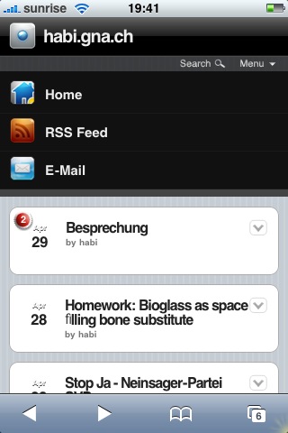
chm, da du meines wissens der einzige regelmässige leser meines blogs bist, der (auch) ein iphone besitzt [1], ist dieser eintrag vor allem (auch) für dich. ich hab’ soeben den WPtouch-plugin installiert, damit mein blog auf dem iPhone und dem iPod touch nett dargestellt wird. sieht nett aus, oder?
für alle, die iphoney nicht installieren wollen, so sieht’s die aktuelle webseite auf dem iPhone aus:

[1]: neopren-sigi vielleicht ja auch, aber dich kann mann ja nicht verlinken…